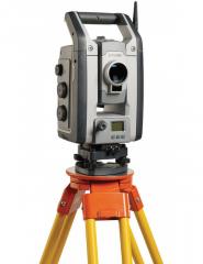
Leica Viva TS16 Total Station
$13,500

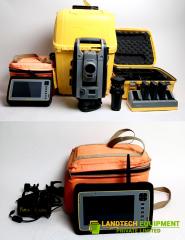
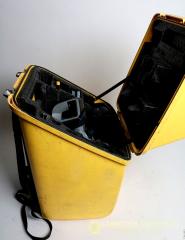
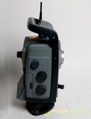
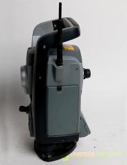
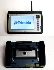
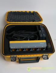
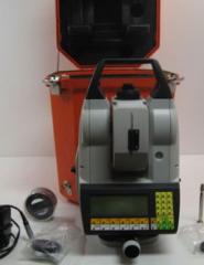
Used Trimble VX 1” Robotic Spatial Station for sale, comes with a Yuma 2 tablet, 5 slot charger, 3 batteries, Yuma bracket and a MT1000 prism. This Trimble VX 1” Robotic Spatial Station was Calibrated by a Trimble Authorized Service Center, in excellent and ready to working condition
Used Trimble VX 1” Robotic Spatial Station for sale includes:
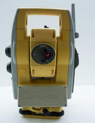
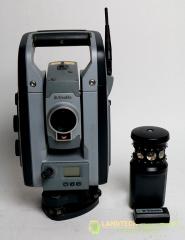
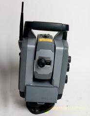
TRIMBLE VX SPATIAL STATION
Capture and combine scanning, imaging and surveying deliverables with the singular solution designed for surveyors. Integrating the technologies of advanced optical surveying, metric imaging and 3D scanning, the Trimble® VX™ Spatial Station is the only surveying instrument that does it all and does it with ease.
CAPTURE THE SHAPE OF THE REAL WORLD - EVERY DAY
Expectations from surveying customers are evolving . To improve the efficiency of capturing advanced Spatial Imaging deliverables, Trimble provides an integrated solution for bringing these technologies together within the traditional workflows surveyors already use. So you have the flexibility to perform feature-rich scans every day, without the complexity of setting up a separate scanning system or switching to specialized field software. With the Trimble VX Spatial Station, you can efficiently capture the information you need to create digital terrain models (DTMs), volume calculations, and perform topographic measurements faster than with traditional surveying methods.
HARNESS THE POWER OF TRIMBLE REALWORKS SOFTWARE
Advanced 3D models and image-rendered 3D surfaces are within your reach with the rich data delivered by Trimble Spatial Imaging sensors. With the ability to capture metric images with the Trimble VX in the field, you are also able to make additional measurements and attribute the data back in the office. It’s all accessible to surveyors with the Trimble VX and Trimble RealWorks® software. Your clients will immediately see the detail of your work via 3D walkthroughs of the job site using your survey data, images, and scanned information all from the Trimble VX
VIDEO-ASSISTED CONTROL
Trimble VISION gives you the power to see everything the instrument sees. Direct your work with live video images on the controller . Now you are free to capture measurements to prism or reflectorless surface with a point and click
COMBINE GNSS AND OPTICAL DATA
Take your productivity even further by adopting Trimble Integrated Surveying™ workflows – simply add your GNSS receiver to your robotic rod and powerful Trimble field software will seamlessly take care of the rest . This allows you to collect GNSS and optical data while simultaneously scanning a surface or site . With the built-in imaging and 3D scanning capabilities, you can capture the shape of objects of interest, such as a nearby building or power lines while you perform your traditional survey work. With the long range capabilities of the Trimble EDM, you measure further with fewer instrument set-ups and enhance your scanning performance.
The Trimble VX Spatial Station is designed for surface scanning, enabling the instrument to measure the shape of a surface for surface modeling and volume calculation. Separating itself from other total stations, it captures and combines scanning, imaging and surveying deliverables. integrating the technology of advanced optical surveying, metric imaging and 3D scanning. The Integrated camera in the VX Spatial station enables the user to frame the area to be scanned and to take snapshots for documentation purposes.
FEATURES:
APPLICATIONS:
TRIMBLE VX SPATIAL STATION SPECIFICATIONS:
| Performance | |
| Scanning (not enabled on all models) | |
| Range | from 1 m up to 250 m (3.28 ft–820 ft) |
| Speed | up to 15 points/sec, typical 5 points/sec |
| Minimum point spacing | 10 mm (0.032 ft) |
| Standard deviation | 3 mm @ ≤150 m (0.0098 ft @ ≤492 ft) |
| Single 3D point accuracy | 10 mm @ ≤150 m (0.032 ft @ ≤492 ft) |
| Angle accuracy | 1” (0.3 mgon) |
| Sensor type | Absolute encoder with diametrical reading |
| Automatic level compensator | |
| Type | Centered dual-axis |
| Accuracy | 0.5” (0.15 mgon) |
| Range | ±5.4' (±100 mgon) |
| Other distance measurement | |
| Accuracy (RMSE) | |
| Prism mode Standard Standard deviation according to ISO17123-4 Tracking |
2 mm + 2 ppm (0.0065 ft + 2 ppm) 1 mm + 2 ppm (0.003 ft + 2 ppm) 4 mm + 2 ppm (0.013 ft + 2 ppm) |
| DR mode Standard Tracking |
2 mm + 2 ppm (0.0065 ft + 2 ppm) 4 mm + 2 ppm (0.013 ft + 2 ppm) |
| Measuring time | |
| Prism mode Standard Tracking |
1.2 sec 0.4 sec |
| DR mode Standard Tracking |
1–5 sec 0.4 sec |
| Range | |
| Prism mode (under standard clear conditions) | |
| 1 prism | 2,500 m (8,202 ft) |
| 1 prism Long Range mode | 5,500 m (18,044 ft) (max. range) |
| Shortest possible range | 0.2 m (0.65 ft) |
| DR mode | |
| Shortest possible range | 1 m (3.28 ft) |
| DR Ranges (typically) | |
| Concrete | 600–800 m (1,968–2,624 ft) |
| Wood construction | 400–800 m (1,312–2,624 ft) |
| Metal construction | 400–500 m (1,312–1,640 ft) |
| Light rock | 400–600 m (1,312–1,968 ft) |
| Dark rock | 300–400 m (984–1,312 ft)) |
| Reflective foil 20 mm | 1,000 m (3,280 ft) |
| Extended Range Mode | |
| White Card (90% reflective) | 2,000–2,200 m |
| Gray Card (18% reflective) | 900–1,000 m |
| Accuracy | 10 mm + 2 ppm (0.033 ft + 2 ppm) |
| Robotic Operation | |
| Range Passive prisms Trimble MultiTrack Target |
500–700 m (1,640–2,297 ft) 800 m (2,625 ft) |
| Autolock pointing precision at 200 m (656 ft) (Standard deviation) Passive prisms Trimble MultiTrack Target |
<2 mm (0.007 ft) <2 mm (0.007 ft) |
| Shortest search distance | 0.2 m (0.65 ft) |
| Type of radio internal/external | 2.4 GHz frequency-hopping, spread-sprectrum radios |
| Search time (typical) | 2–10 sec |
| System Specifications | |
| Leveling Circular level in tribrach Electronic 2-axis level in the LC-display with a resolution of |
8'/2 mm (8’/0.007 ft) 0.3” (0.1 mgon) |
| Servo system | MagDrive servo technology, integrated servo/angle sensor electromagnetic direct drive |
| Rotation speed | 115 degrees/sec (128 gon/sec) |
| Rotation time Face 1 to Face 2 | 2.6 sec |
| Positioning speed 180 degrees (200 gon) | 2.6 sec |
| Clamps and slow motions | Servo-driven, endless fine adjustment |
| Centering | |
| Centering system | Trimble 3-pin |
| Optical plummet | Built-in optical plummet |
| Magnification/shortest focusing distance | 2.3×/0.5 m to infinity (1.6 ft to infinity) |
| Telescope | |
| Magnification | 30x |
| Aperture | 40 mm (1.57 in) |
| Field of view at 100 m (328 ft) | 2.6 m at 100 m (8.5 ft at 328 ft) |
| Shortest focusing distance | 1.5 m (4.92 ft) to infinity |
| Illuminated crosshair | Variable (10 steps) |
| Autofocus | Standard |
| Camera | |
| Chip | Color Digital Image Sensor |
| Resolution | 2048 x 1536 pixels |
| Focal length | 23 mm (0.07 ft) |
| Depth of field | 3 m to infinity (9.84 ft to infinity) |
| Field of view | 16.5° x 12.3° (18.3 gon x 13.7 gon) |
| Digital zoom | 4-step (1x, 2x, 4x, 8x) |
| Exposure | Automatic |
| Brightness | User-definable |
| Contrast | User-definable |
| Image storage | Up to 2048 x 1536 pixels |
| File format | JPEG |
| Compression ratio | User-definable |
| Video streaming | 5 frames/sec |
| Operating temperature | –20 ºC to +50 ºC (–4 ºF to +122 ºF) |
| Dust and water proofing | IP55 |
| Power supply | |
| Internal battery | Rechargeable Li-Ion battery 11.1 V, 4.4 Ah |
| Operating time One internal battery Three internal batteries in multi-battery adapter Robotic holder with one internal battery |
Approx. 5 hours Approx. 15 hours Approx. 12 hours |
| Weight | |
| Instrument | 5.25 kg (11.57 lb) |
| Tribrach | 0.7 kg (1.54 lb) |
| Internal battery | 0.35 kg (0.77 lb) |
| Trunnion axis height | 196 mm (7.71 in) |
| Communication | USB, Serial, Bluetooth |
| Security | Dual-layer password protection |
| EDM Specifications | |
| Light source | Pulsed Laser diode 905 nm; Laser class 1 |
| Laser pointer coaxial | Laser class 2 |
| Beam divergence Prism mode | |
| Horizontal | 4 cm/100 m (0.13 ft/328 ft) |
| Vertical | 8 cm/100 m (0.13 ft/328 ft) |
| Beam divergence DR mode | |
| Horizontal | 4 cm/100 m (0.13 ft/328 ft) |
| Vertical | 8 cm/100 m (0.13 ft/328 ft) |
| Atmospheric correction | –130 ppm to 160 ppm continuously |